Page 2 of 6 FirstFirst 123456 LastLast
Results 21 to 40 of 120

Thread: Iraq looks too arid! It's not a desert. More greenery, please

  1. #21
    bigdaddy1204's Avatar Campidoctor
    Join Date
    Mar 2007
    Location
    Dar al-Islam
    Posts
    1,896

    Default Re: Iraq looks too arid! It's not a desert. More greenery, please

    Also, one more small detail - I noticed that the area at the bottom right corner of the map, immediately above the 'port' shown on the campaign map just along the south edge of the Zagros mountains, is the area where the ancient city of Susa was located. Susa was an important city of the Elamite, Persian and Parthian empires until it was destroyed by the Mongols in 1218. A small town still exists on the spot. That area receives a fair bit of rainfall because of the Zagros mountains, where clouds shed rain on the slopes which collect in the land at the bottom. Today it is part of the Iranian region of Khuzestan and it has the city of Izeh. Would be nice to see a touch of green over there

    Here's a map showing its exact location, and a photo of the area today:


    Last edited by bigdaddy1204; June 19, 2015 at 12:54 PM.

  2. #22

    Default Re: Iraq looks too arid! It's not a desert. More greenery, please

    It doesn't matter if the Mongols destroyed something in 1258, as I see in the screenshots that your mod starts in 1132.

  3. #23
    Lifthrasir's Avatar "Capre" Dunkerquois
    Patrician took an arrow to the knee

    Join Date
    Jan 2010
    Location
    City of Jan Baert
    Posts
    13,950
    Blog Entries
    4

    Default Re: Iraq looks too arid! It's not a desert. More greenery, please

    Quote Originally Posted by bigdaddy1204 View Post
    This is much better! Good job

    I liked the edits you have made. Now a couple of more points - including one very important!

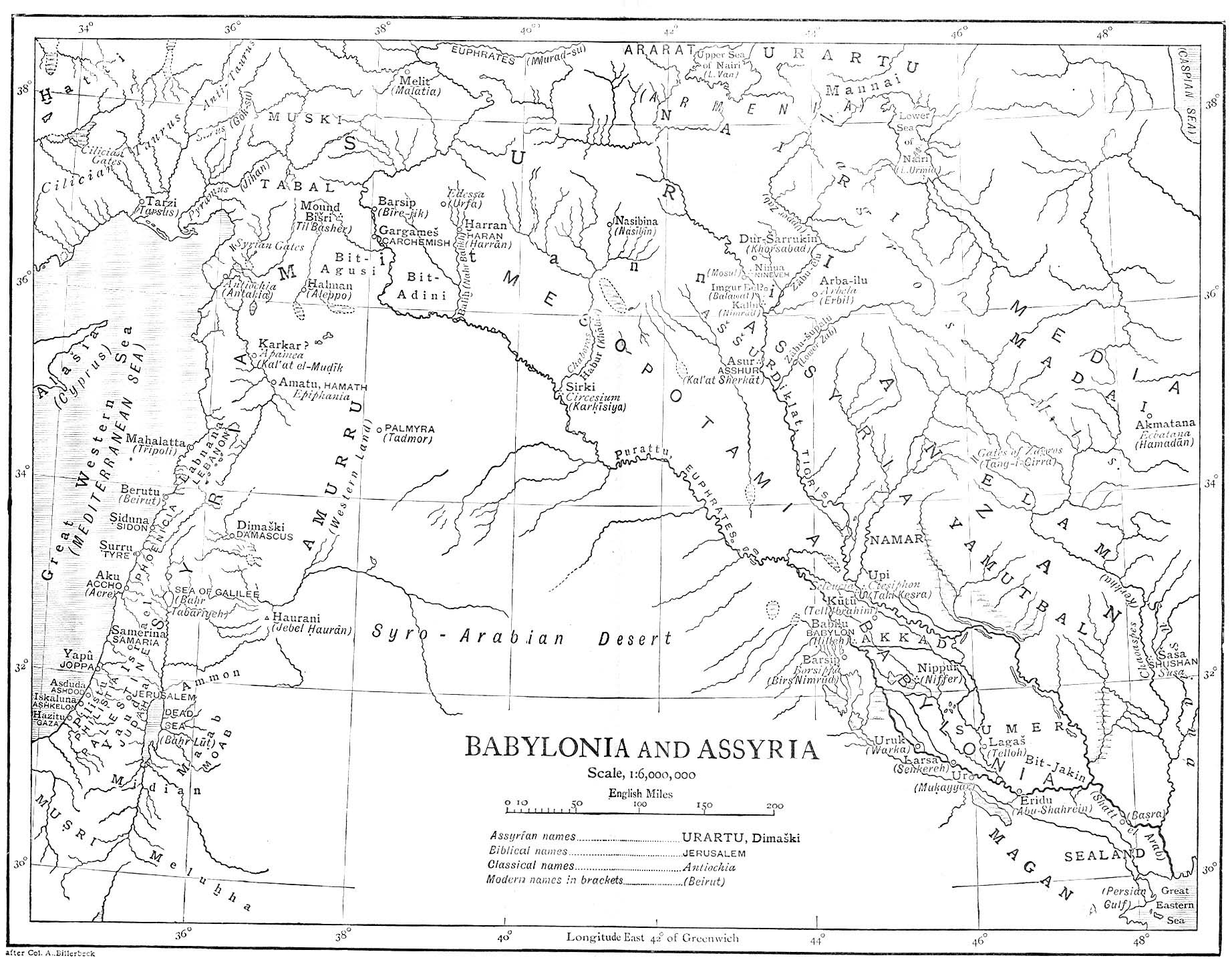
    1). I just realised that lake Tharthar (the big lake at the top left) is on the wrong side of the Tigris river! To be more exact, the lake is in the right place, but the Tigris river (incorrectly) flows to the east of the lake, whereas in reality it should flow directly west from Baghdad, skirting the west side of the lake!

    This is quite a big mistake and never noticed it before! if you could redirect the river so that it goes to the left of the lake, instead of the right, that would be useful!

    2). Also, the area around lake Tharthar is known for the ziziphus trees that grow around it, and it is a major source of irrigation water for farming. It would be good to add some trees on that area.

    Good work MWY, we are making great progress!
    Good spot!!! But I think you mean Euphrates river and not Tigris river.
    Tigris river is the one on the East of Bagdad, right?
    Under the patronage of Flinn, proud patron of Jadli, from the Heresy Vault of the Imperial House of Hader

  4. #24
    bigdaddy1204's Avatar Campidoctor
    Join Date
    Mar 2007
    Location
    Dar al-Islam
    Posts
    1,896

    Default Re: Iraq looks too arid! It's not a desert. More greenery, please

    Quote Originally Posted by Lifthrasir View Post
    Good spot!!! But I think you mean Euphrates river and not Tigris river.
    Tigris river is the one on the East of Bagdad, right?
    Oops! Yes I meant Euphrates, you are correct

  5. #25

    Default Re: Iraq looks too arid! It's not a desert. More greenery, please

    Newest version:


    So how about syria/kurdistan?

  6. #26
    bigdaddy1204's Avatar Campidoctor
    Join Date
    Mar 2007
    Location
    Dar al-Islam
    Posts
    1,896

    Default Re: Iraq looks too arid! It's not a desert. More greenery, please

    Quote Originally Posted by MWY View Post
    Newest version:


    So how about syria/kurdistan?
    Thanks, looking good! This is a significant improvement on the original.

    I still think the Zagros mountains could be a bit greener, especially the section to the north-east of al Wasit where the rivers come down, running in a curve round to where Susa is. Other than that, this looks great and I am excited to see it in my future campaigns.

    As for Kurdistan, I looked again at the map and checked things out and actually I think it's pretty accurate as it is. I looked at two further areas:

    1). The Tigris between Baghdad and Mosul
    2). The Ephrates between Baghdad and Raqqa

    For 1). I noticed that there is significant settlement (towns, villages) on the east side of the Tigris between it and the Zagros mountains - it seems that entire large area is well inhabited. But there is absolutely nothing at all to the west of the river!

    As for 2). I noticed that it's a bit like the Nile valley: it's a deeply cut valley with settlement only along a very narrow strip close to the water. There are some important towns though, including Falluja, which is west of Baghdad.

    So it would be safe to 'green up' the countryside east of the Tigris between Baghdad and Mosul, right the way from the banks of the river all the way to the mountain slopes of the Zagros. Other than that, no other changes.

  7. #27
    Lifthrasir's Avatar "Capre" Dunkerquois
    Patrician took an arrow to the knee

    Join Date
    Jan 2010
    Location
    City of Jan Baert
    Posts
    13,950
    Blog Entries
    4

    Default Re: Iraq looks too arid! It's not a desert. More greenery, please

    Good job MWY!!!
    My only comment would be for the area between al-Wasit, al-Basra and the mountains. I guess that it should look like the area between the Tigris and Euphrates rivers as suggested by Bigdaddy1204.
    Under the patronage of Flinn, proud patron of Jadli, from the Heresy Vault of the Imperial House of Hader

  8. #28

    Default Re: Iraq looks too arid! It's not a desert. More greenery, please

    I really dont think so. To be honest, I think the area between the rivers is already too green. All the sources I find definitely dont say it was a second nile delta back then.

    But I'll see what I can do.

  9. #29

    Default Re: Iraq looks too arid! It's not a desert. More greenery, please

    Syria:


    Iraq:


  10. #30
    Lifthrasir's Avatar "Capre" Dunkerquois
    Patrician took an arrow to the knee

    Join Date
    Jan 2010
    Location
    City of Jan Baert
    Posts
    13,950
    Blog Entries
    4

    Default Re: Iraq looks too arid! It's not a desert. More greenery, please

    That's fine for me MWY. Good job
    Under the patronage of Flinn, proud patron of Jadli, from the Heresy Vault of the Imperial House of Hader

  11. #31
    bigdaddy1204's Avatar Campidoctor
    Join Date
    Mar 2007
    Location
    Dar al-Islam
    Posts
    1,896

    Default Re: Iraq looks too arid! It's not a desert. More greenery, please

    Quote Originally Posted by Lifthrasir View Post
    That's fine for me MWY. Good job
    Agreed - good work!

    How will I be able to access the new map? Will it appear in a future release?

  12. #32

    Default Re: Iraq looks too arid! It's not a desert. More greenery, please

    Have you guys seen this map?
    The Tigris had a different course than today back in the middle ages, not sure but according to the history something happened in the XV or XVI century which made it change to modern day course.
    Spoiler for map


  13. #33
    Lifthrasir's Avatar "Capre" Dunkerquois
    Patrician took an arrow to the knee

    Join Date
    Jan 2010
    Location
    City of Jan Baert
    Posts
    13,950
    Blog Entries
    4

    Default Re: Iraq looks too arid! It's not a desert. More greenery, please

    Wowww That changes a lot of things. At least, we can see how the swamp mentionned by bigdaddy1204 looked like. About the Tigris river, I need to check that There must be other sources about that point.
    Many thanks Melooo182 for the input
    Under the patronage of Flinn, proud patron of Jadli, from the Heresy Vault of the Imperial House of Hader

  14. #34
    bigdaddy1204's Avatar Campidoctor
    Join Date
    Mar 2007
    Location
    Dar al-Islam
    Posts
    1,896

    Default Re: Iraq looks too arid! It's not a desert. More greenery, please

    Quote Originally Posted by Lifthrasir View Post
    Wowww That changes a lot of things. At least, we can see how the swamp mentionned by bigdaddy1204 looked like. About the Tigris river, I need to check that There must be other sources about that point.
    Many thanks Melooo182 for the input
    Wow, even I hadn't realised that was the location of the swamp area. This does mean a few changes will be needed to the map - specifically, the area to the west and south of the Euphrates river will need to be turned into marshland and swamp all the way from the same latitude as Waset right down to Basra.

    Also, it appears we underestimated the area shown as Khusestan on the map above. On our map, it's still mostly desert whereas the map posted by Melooo182 shows it as an area with rich river basins and lots of settlement, reaching right from Basra up to the Zagros mountains.

    I think MWY is doing a great job and really appreciate his efforts on the campaign map. MWY, we are waiting for you!
    Last edited by bigdaddy1204; June 23, 2015 at 06:31 AM.

  15. #35
    Lifthrasir's Avatar "Capre" Dunkerquois
    Patrician took an arrow to the knee

    Join Date
    Jan 2010
    Location
    City of Jan Baert
    Posts
    13,950
    Blog Entries
    4

    Default Re: Iraq looks too arid! It's not a desert. More greenery, please

    I've done some researches but I haven't found something like that yet. However, it seems that the Tigris river splitted in 2 ways: one like its actual location and another one going straigth South, down to the lake in North of the big swamp. I keep searching.
    Under the patronage of Flinn, proud patron of Jadli, from the Heresy Vault of the Imperial House of Hader

  16. #36
    Lifthrasir's Avatar "Capre" Dunkerquois
    Patrician took an arrow to the knee

    Join Date
    Jan 2010
    Location
    City of Jan Baert
    Posts
    13,950
    Blog Entries
    4

    Default Re: Iraq looks too arid! It's not a desert. More greenery, please

    I've found the following map which shows that Euphrate was a big more to East compare to the present days in its South part.
    (http://www.sacred-texts.com/ane/mba/img/hrmap.jpg to zoom that pic).

    It has been also confirmed by another site where I read the same point. It was still the case during the 12th century. I keep searching.
    Under the patronage of Flinn, proud patron of Jadli, from the Heresy Vault of the Imperial House of Hader

  17. #37
    Lifthrasir's Avatar "Capre" Dunkerquois
    Patrician took an arrow to the knee

    Join Date
    Jan 2010
    Location
    City of Jan Baert
    Posts
    13,950
    Blog Entries
    4

    Default Re: Iraq looks too arid! It's not a desert. More greenery, please

    This what I could find:
    In general character the lands of Sumer and Akkad consist of a flat alluvial plain, and form a contrast to the northern half of the Tigris and Euphrates valley, known to the Greeks as Mesopotamia and Assyria. These latter regions, both in elevation and geological structure, resemble the Syro-Arabian desert, and it is only in the neighbourhood of the two great streams and their tributaries that cultivation can be carried out on any extensive scale. Here the country at a little distance from the rivers becomes a stony plain, serving only as pasture-land when covered with vegetation after the rains of winter and the early spring. In Sumer and Akkad, on the other hand, the rivers play a far more important part. The larger portion of the country itself is directly due to their action, having been formed by the deposit which they have carried down into the waters of the Gulf. Through this alluvial plain of their own formation the rivers take a winding course, constantly changing their direction in consequence of the silting up of their beds and the falling in of the bajiks during the annual floods.
    Of these two rivers the Tigris, owing to its higher and stronger banks, has undergone less change than the Euphrates. It is true that during the Middle Ages its present channel below Kut el-Amara was entirely disused, its waters flowing by the Shatt el-Hai into the Great Swamp which extended from Kufa on the Euphrates to the neighbourhood of Kurna, covering an area fifty miles across and nearly two hundred miles in length. But in the Sassanian period the Great Swamp, the formation of which was due to neglect of the system of irrigation under the early caliphs, did not exist, and the river followed its present channel. It is thus probable that during the earlier periods of Babylonian history the main body of water passed this way into the Gulf, but the Shatt el-Hai may have represented a second and less important branch of the stream. The change in the course of the Euphrates has been far more marked, the position of its original bed being indicated by the mounds covering the sites of early cities, which extend through the country along the practically dry beds of the Shatt en-Nil and the Shatt el-Kar, considerably to the east of its present channel. The mounds of Abu Habba, Tell Ibrahim, El-Ohemir and Niffer, marking the sites of the important cities of Sippar, Cutha, Kish and Nippur, all lie to the east of the river, the last two on the ancient bed of the Shatt en-Nil. Similarly, the course of the Shatt el-Kar, which formed an extension of the Shatt en-Nil below Suk el-Afej passes the mounds of Abu Hatab (Kisurra), Fara (Shuruppak) and Hammam. Warka (Erech) stands on a further continuation of the Shatt en-Nil, while still more to the eastward are the mounds of Bismaya and Jokha, representing the cities of Adab and Umma. Senkera, the site of Larsa, also lies considerably to the east of the present stream, and the only city besides Babylon which now stands comparatively near the present bed of the Euphrates is Ur. The positions of the ancient cities would alone be sufficient proof that, since the early periods of Babylonian history, the Euphrates has considerably changed its course.
    This has been confirmed by other sources but this one seems to be the most detailed. Anyway, based on this and on the map posted by Melooo182, I made the map below for Mesopotamia:


    The actual stream of the Euphrate should be removed (in red) and replaced by the one further East (blue). The Tigris river had another stream (more a secondary one, the actual one being the most important even at that time), starting from Kut and going Southward to the Great Swamp (dark green area). In light green, I've put the areas which should be slightly "greener" from my point of view. Note that the area between the Tigris river and the mountains should be "greener from Bagdad to Mosul (not on that map).

    This is just a suggestion. Comments are welcome


    This is just a suggestion
    Under the patronage of Flinn, proud patron of Jadli, from the Heresy Vault of the Imperial House of Hader

  18. #38
    bigdaddy1204's Avatar Campidoctor
    Join Date
    Mar 2007
    Location
    Dar al-Islam
    Posts
    1,896

    Default Re: Iraq looks too arid! It's not a desert. More greenery, please

    Quote Originally Posted by Lifthrasir View Post
    This what I could find:

    This has been confirmed by other sources but this one seems to be the most detailed. Anyway, based on this and on the map posted by Melooo182, I made the map below for Mesopotamia:


    The actual stream of the Euphrate should be removed (in red) and replaced by the one further East (blue). The Tigris river had another stream (more a secondary one, the actual one being the most important even at that time), starting from Kut and going Southward to the Great Swamp (dark green area). In light green, I've put the areas which should be slightly "greener" from my point of view. Note that the area between the Tigris river and the mountains should be "greener from Bagdad to Mosul (not on that map).

    This is just a suggestion. Comments are welcome


    This is just a suggestion
    Well done Lifthrasir!

    This is very impressive. So does this mean that the shaded area (in green) to the south on the Euphrates should become a large swamp? And does Medieval II engine give us the ability to depict swamp land? Would it involve lots of trees and wetland area?

    These changes look great. The only further suggestion I'd add would be a big change to the Khuzestan area east of Basra. (I have put this area in red stripes). After researching this area, I found the following description:

    The province of Khuzestan is irrigated by the Karoun, Karkheh, Jarahi and Maroun rivers. Khuzestan has great potential for agricultural expansion, which is almost unrivaled by the country's other provinces. Large and permanent rivers flow over the entire territory contributing to the fertility of the land.

    From this description and checking maps, I can see that the red striped area should actually be a fertile system of rivers flowing down into the Persian Gulf, with rich farmlands all around.


  19. #39
    Lifthrasir's Avatar "Capre" Dunkerquois
    Patrician took an arrow to the knee

    Join Date
    Jan 2010
    Location
    City of Jan Baert
    Posts
    13,950
    Blog Entries
    4

    Default Re: Iraq looks too arid! It's not a desert. More greenery, please

    Yep, I agree about the Khuzestan but I wasn't sure.

    Regarding my suggestion, there are 2 points for which I'm not sure it can be done:
    - the 2nd stream of the Tigris river: I'm not sure that a river can join another river by 2 separate points due to the engine. That's something we have to try. If not possible, we just need to cancel it as it was not the main stream of the Tigris river anyway.
    - the Grat Swamp: I'm also not sure that we can set swamps for that climate. The best option would be to have swamps (without the forest of course) like between Turov and Polotsk in Russia. In the worst case, an alternative solution could be to make that area like the Nil delta and add a few small lakes. Regarding trees, I'm not sure there were a lot of them. By adding just a few of them like in the other areas of Mesopotamia should do. It's quite difficult to find good sources between the Roman period and the 18th-19th centuries. The document I put in quote is one of the rare documents I could find mentionning something about the 12th century.

    Let's see if MWY can do something.
    Last edited by Lifthrasir; June 26, 2015 at 08:34 AM.
    Under the patronage of Flinn, proud patron of Jadli, from the Heresy Vault of the Imperial House of Hader

  20. #40

    Default Re: Iraq looks too arid! It's not a desert. More greenery, please


Page 2 of 6 FirstFirst 123456 LastLast

Posting Permissions

  • You may not post new threads
  • You may not post replies
  • You may not post attachments
  • You may not edit your posts
  •